−−− BY LINZI DAVIES −−−
May is the national walking month and Yorkshire is certainly a beautiful place in which to have a ramble! Fresh air and stunning scenery combined with exercise give you that feel-good factor both mentally and physically. Now the days are longer and dare I say warmer; May is the perfect time to get out and about after being cooped up over the winter months. Having looked at some lovely Yorkshire walks in previous years, this month we are focussing on the glorious Cleveland Way which celebrates its 50th anniversary on the 24th, making it even more special! We discover the history of the trail, and some of its most popular walks, plus look at the events running to celebrate its anniversary.
THE CLEVELAND WAY
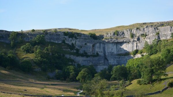
The Cleveland Way is 109 miles long, taking in all that Yorkshire has to offer, from the dramatic coastline to heather moorland and castles to coves. Development of the trail began in the 1930’s when the Teesside Rambler’s Association called for a long-distance path in the north-east of Yorkshire to be created. In 1953 a formal proposal to create the route was submitted to the council, and the trail officially opened on the 24th May 1969 – the second official National Trail to be opened. National Trails are administered by Natural England, a UK Government agency.
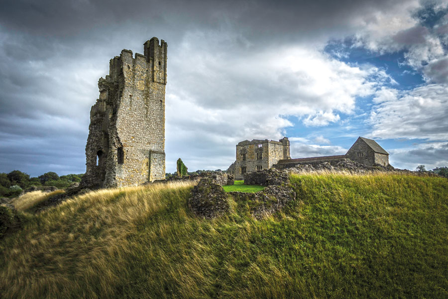
■ Helmsley Castle. Wikimedia Commons image © Barkmatter
The Cleveland Way runs from Helmsley to Filey and can be walked in either direction, although most people prefer to walk it in a clockwise direction from Helmsley towards the coast. It is accessible all year round, providing changing scenery with the seasons, but if you want to see the moorland heather in full bloom this happens in late August and September.
There are one-and two-day circular walks as well as shorter easy access walks to enjoy. The trail is well signposted with the acorn symbol, but it is advised that you take your own map, walk guide or GPS and do not rely on them alone as the weather can be unpredictable. You will also find that the trail is made up of footpath, bridleway and byway so make sure you take notice of the status of section you are on so that you are aware what other users may be present such as cyclists, horse riders and even vehicles. The status is indicated on the signposts with either a yellow, blue or red arrow respectively.
Popular Walks
Helmsley Castle to Rievaulx Abbey 11.3km (7miles)
Probably the one of the most well-known walks along the Cleveland Way – and for good reason! This walk takes in the Medieval magnificence of Yorkshire, following in the footsteps of Saint Aelred of Rievaulx through woodland, the valley of Blackdale Howl and of course the top of Jinny York Bank which give you stunning views across the landscape. Helmsley Castle dates back to the 12th century when it was a medieval fortress before evolving into a Tudor Manor House. It is now managed by English Heritage and the ruins are well worth a visit, as is the picturesque town itself where you might also want to visit Helmsley Brewery and the National Centre for Birds of Prey.
Rievaulx Abbey was founded in 1132 and in its heyday was home to over 140 monks who transformed the site into a busy hub of industry. It provided fertile farmland and also smelted iron. Today, the ruins are a place of beauty, offering a haven of relaxation for a time before you return to Helmsley and complete the walk.
Sutton Bank – south walk 4.8km (3miles), north walk 11.5km (7miles)
On the edge of the North York Moors National Park, Sutton Bank provides incredible views over the Vale of Mowbray. There are two walks to enjoy which both set out from the Sutton Bank National Park Centre. The first takes you south around Roulston Scar to the White Horse of Kilburn which measures 318ft long by 220ft high, covering about 1.6 acres of land. The horse was formed by removing the topsoil and exposing the underlying sandstone rock before being covered with white limestone chips. It was created in 1857, some say by school master John Hodgson and his pupils, and others say it was thanks to Thomas Taylor a native of Kilburn who had been inspired by visiting the Uffington White Horse. This famous landmark can even be seen from north Leeds on a clear day and makes a great photo opportunity along your walk.
The second walk available to you is to head north from the National Park Centre to a viewpoint on the edge of Sutton Bank which author James Herriot described as ‘England’s finest view’. You can look out over Garbutt Wood, a haven for wildlife and Gormire Lake which was formed during the last Ice Age.
Hasty Bank and Wainstones – short walk 3.8km (2.4miles), long walk 12km (7.5miles)
This is a more challenging walk which is well worth the added effort! A scramble up the Wainstones using your hands offers the reward of panoramic views of the surrounding heather moorland and fields below. The heather moorland looks spectacular in late August – September when it is full bloom, showing off its purple glory! The moorland is home to grouse and other breeding birds such as golden plover so look out for them too. The altitude and exposed position of the Wainstones mean you will need suitable outdoor clothing, and take a picnic with you – the many rock faces offer dry shelter for a well-earned lunch break all year round. As well as nature to witness, human history is also present here if you look out for the names of those who have visited over many years carved into the rocks.
Roseberry Topping to Great Ayton circuit 11.7km (7.3miles)
This circular walk from Great Ayton takes in two iconic features of the Cleveland Way – Roseberry Topping, and Captain Cook’s Monument. If you are walking with children, Roseberry Topping will easily be mistaken for a huge mountain and reaching the summit will make them feel on top of the world! The steep sided hill is capped with hard sandstone, and the top offers 360-degree views of the northern moors. Captain Cook’s Monument on Easby Moor was erected in 1827 to honour the world-famous Yorkshire explorer who was born in the area in 1728, at Airey Hill Farm which is visible just below Roseberry Topping. It is exciting to think as you walk the area, that this intrepid explorer who discovered the eastern coastline of Australia, would have spent much of his formative years stomping the same ground! Great Ayton is a great start and end to the walk to enjoy refreshments in the cafes and pubs.
Saltburn – 6.9km (4.3miles)
Saltburn is where the Cleveland Way hits the coast, and if you are an art lover then this stretch is a must! Saltburn is a charming Victorian seaside resort with a history of smuggling. Today, it is a haven for surfers and the creative arts, with a good range of cafes, restaurants and bars in which to enjoy refreshments. In 1990, artist Richard Farrington was commissioned to produce three sculptures which represent the area which you can enjoy along your walk. There is a large fish, a striking marker post and ‘The Ring’ with ten charms suspended from it – each of which shows a story of local folklore or tradition. All the sculptures are made from steel so provide music in the breeze as well as a visual feast. All this is in addition to the breath-taking clifftop views!
Robin Hood’s Bay – 2km (1.2miles)
This shorter circular walk is ideal for families to enjoy with children. The distance is easily doable for little legs and they will be having so much fun hunting out fossils that they won’t notice getting tired anyway! During the time of the dinosaurs, Robin Hood’s Bay was a deep sea bed, and the fossils that have been left behind of creatures that used to live under the sea are in clear evidence if you look carefully. The many rock pools also offer exciting opportunities to spot living things such as starfish, crabs and sea anemones that may have been abandoned until the next high tide. Robin Hood’s Bay was also once a well-known haven for smugglers so children’s imaginations can run wild with tales of hidden booty. The Old Coastguard Station at The Dock hire out The Coast Alive Tracker Packs free of charge, which include a route map, binoculars, magnifying glass and suggestions for family activities.
Scarborough to Filey – 16.7km (10.5miles)
Filey marks the end of the Cleveland Way, and this walk between the two towns offers stunning cliff and coastal scenery to enjoy along your journey. Scarborough is a thriving spa town with lots to see, do and eat! The castle looking down over the town makes for a great historical visit before you begin the walk. As you leave the town you see the location of the former Holbeck Hall Hotel which famously slipped into the sea in 1994. The area is renowned for coastal slippage and there are some bungalows hanging in the balance too. The walk passes Cayton Bay before you reach Filey Brigg which is a birdwatcher’s paradise. Celebrate reaching the end of the Cleveland Way in Filey with a well-deserved drink and something to eat. There are frequent buses that run between the two towns, so the good news is that you don’t have to walk all the way back – unless you want to of course!
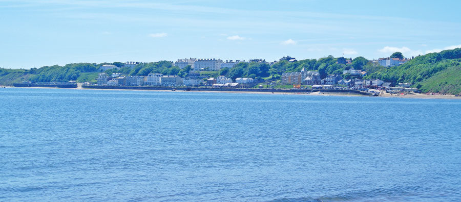
■ Filey viewed from Filey Brigg
50th Anniversary Celebrations and Events
There are plenty of events to celebrate the 50th anniversary of the Cleveland Way to get involved in. Here is a selection.
12th May – A Joint Celebration! Cleveland Way 50th and Gisborough Priory 900th
Celebrate the 50th anniversary of the Cleveland way by walking a stretch on the North York Moors before stepping further back in time at the ruins of Gisborough Priory to mark 900 years since it was founded by Robert de Brus.
This event is organised by the OutdoorLads who run a range of sociable outdoor activities for gay, bi and trans men. All welcome.
£10 per ticket available from www.outdoorlads.com/events
16th May – 900 Years of History (1.5miles approx. 2hrs)
A gentle stroll through Skelton learning a little about the 900-year history of the village of Skelton – in – Cleveland. The walk takes you through time from a 12th century font to a 21st century mosaic mural! Meet in Church Lane, Skelton at 10.30am.
18th May – Victorian Saltburn (1mile, approx. 2hrs)
Explore Saltburn’s Victorian Heritage and how it came to be. Discover why it is now such a special place. Meet under Saltburn Station Portico at 2pm.
20th May – North by Northwest (4miles approx. 2.5hrs)
A good level of fitness is needed for this walking event as there is a height gain of around 100 metres. View some of the industrial heritage of East Cleveland on your way to the destination of the Guibal fan house which served Huntcliff ironstone mine. Meet at Skinningrove sea front car park at 10.30am.
22nd May – Skinningrove Valley Trail (3miles approx. 2.5hrs)
This is a stroll through Skinningrove looking at the village’s rich industrial and social history, as well as how it continues to evolve. Meet at Skinningrove sea front car park at 10.30am
24th May – Steam, Steel and Scenery (4 miles approx. 4hrs)
Celebrating the 50th anniversary of the Cleveland Way on the exact date, this walk begins from Loftus taking you on a journey through the industrial heritage of steam locomotion, iron making, and the legacy of the people involved in it. The walk includes views over Kilton and out to sea. Meet outside Loftus Library at 10.30am
The above 5 walks are all organised by Skelton History Group and Loftus ACCORD Walking group. They are all free of charge with no need to book in advance.
For more information on all the events visit
www.nationaltrail.co.uk/cleveland-way/events